|
Home
Up
Search
Multi-County DVDs
Southeast Missouri
Ozark Region
Arkansas Counties
Illinois Counties
Indiana Counties
Iowa Counties
Kansas Counties
Kentucky Counties
Louisiana Parishes
Massachusetts Vital Records
North Carolina Counties
Ohio Counties
Pennsylvania Counties
Tennessee Counties
Texas Counties
Historic Map Reprints
Plat Map Books
Census Records
State County Maps
New Titles
Coming Soon
Questions Answers
Customer Quotes
Wholesale
Conferences
Missouri Journey
Iris Median
Contact Us
Genealogy History News
Special Offers
County History Books
| |
Additional
Free Genealogy and Map Resources
 St.
Clair County, Missouri History and Genealogy St.
Clair County, Missouri History and Genealogy
400+ Page 1883 History of St. Clair County history and
genealogy including more
than 300 biographies plus 34 different St. Clair County communities on 6
different maps
An informative and historical overview of St. Clair
County, Missouri including three separate sections on one CD which include 6
historical maps (1851, 1902, 1904, 1913, 1920's and 1929: these 6 maps show a
total of 34 different communities); plus the full 1883 National Historical
Company History of St. Clair County, Missouri book (over 400 pages of history
with over 300 different biographies). An important resource for the study
and research of St. Clair County, Missouri history and genealogy.
Fully
searchable - find any name or location instantly!
This fascinating and detailed CD contains all of the following material on
three
separate sections, ALL on one CD:
Section One on CD:
Maps of St. Clair County, Missouri
Included here are the west central region of Missouri sections of 6 different
historical maps:
A. A rare 1851 map that shows the area of St. Clair County just 10 years after
St. Clair County was formed.
B. A map of 1902 St. Clair County showing the locations of 19 different
settlements including all of the following: Appleton City * Baker * Catherine *
Chalklevel * Cobb * Collins * Griesel * Iconium * Johnson City * Lowry City *
Monegaw Springs * Ohio * Osceola * Oyer * Pape * Roscoe * Taberville * Terry *
Vista *
C. A map of 1904 St. Clair County showing the locations of 31 different
settlements including all of the following: Appleton City * Baker * Catherine *
Chalklevel * Chloe * Cobb * Copeland * Corbin * Damascus * Donia * Dwight * Ebb
* Gerster * Harper * Iconium * Iuka Springs * Johnson City * Lowry City *
Monegaw Springs * Ohio * Osceola * Oyer * Pape * Rainey * Rookins * Roscoe *
Taberville * Terry * Tiffin * Valhalla * Vista *
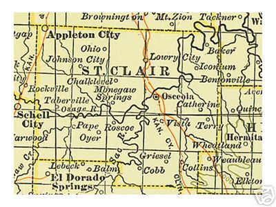
The 1904 map of St. Clair County can be viewed here:
St. Clair County, Missouri 1904 Map
D. A map of 1913 St. Clair County showing the locations of numerous schools
and chuches, the townships plus 34 different settlements including all of the
following: Appleton City * Baker * Catherine * Chalklevel * Chloe * Cobb *
Collins * Copeland * Corbin * Damascus * Donia * Dwight * Ebb * Gerster *
Griesel * Harper * Iconium * Iuka Springs * Johnson City * Lowry City * Monegaw
Springs * Ohio * Osceola * Oyer * Pape * Rainey * Rookins * Roscoe * Taberville
* Terry * Tiffin * Valhalla * Vista * Whitley *
E. A map from the 1920's which includes details of where various tourist
sites and service stations were located.
F. A 1929 map from the Missouri Department of Transportation. You will be
amazed at how many of the major routes were only dirt or gravel!
Section Two on CD:
St. Clair County, Missouri in 1913
Included here are five pages concerning St. Clair County from the 1913 edition
of The Missouri Red Book and contains about every imaginable statistic you could
want for this time period. Some of the facts contained are the number of farms
and their acreages, number of cows, horses, mules, pigs, sheep, goats, poultry,
colonies of bees, how many farms had mortgages and how many were free of debt,
the amount of butter produced, the number of bushels of apples, peaches, pears,
etc. harvested, the number of quarts of blackberries harvested, the number of
schools and teachers, plus hundreds of other detailed statistics. A wealth of
information concerning St. Clair in 1913!
Section Three on CD:
The complete 1883 National Historical Company History of St. Clair County,
Missouri
This detailed (400+ pages in all) book has an incredible amount of historical
and genealogical information
about St. Clair County, Missouri from its earliest settlement up to 1883. This is an
exact photo replica of all the pages pertaining to St. Clair County, Missouri
including all of the historical and biographical information. Included are a
total of more than 300 different biographies.
Here is just some of the information included:
-
The Valley of the Osage
-
Pioneers and Progress in St. Clair County
-
An Old Settlement - Wild Beast of the Mountains
-
The Birth of St. Clair County, Missouri
-
A Combination of Solid Facts Makes History
-
A Chapter Which Refers To The Pocket
-
St. Clair County Its Physical Features Resources
-
Railroads vs. No Railroads
-
Evidences of Fraud and the Legal Fight
-
Men's Passions Having Full Sway - Crimes in St. Clair County
-
St, Clair County Officials and County Politics
-
Odds and Ends of St. Clair County
-
St. Clair County War Record - Press - Early Bar
-
Osceola Township
-
Appleton Township
-
Monegaw and Chalk Level Townships
-
Butler, Jackson and Polk Townships
-
Dallas, Collins, Doyal & Washington Townships
-
Roscoe, Taber and Speedwell Townships
-
St. Clair County Biographies by Township
Included is a total of more than 300 St. Clair County family biographies
(valuable for genealogy) including each of the
following surnames (NOTE: thousands of other surnames are also mentioned throughout the text and within
these biographies)
To view
a sample family biography, click here Addams * Allen * Amlin * Ammons * Anderson * Arnold * Babb *
Barnett * Barr * Baugh * Bazzill * Beach * Bell * Bishop * Bollinger * Booth *
Boots * Bothwell * Bowles * Bramnan * Branson * Brown * Browning * Burch * Burns
* Buskirk * Butcher * Calmes * Campbell * Carr * Carroll * Carver * Cauthon *
Chapel * Choice * Clark * Clear * Cleveland * Cock * Cockrell * Coffin * Collins
* Conaut * Conn * Cook * Coonce * Cooper * Copenhaver * Corbin * Cornelius *
Cowin * Cox * Craig * Daniel * Davidson * Davis * Dawson * Delozier * Disney *
Ditty * Dodge * Dooley * Dowers * Dudley * Edwards * Egger * Elgan * Elliott *
Emerson * English * Estes * Evans * Everett * Eye * Farnham * Ferguson *
Fletcher * Freeman * French * Fuqua * Gardner * Garnett * Gash * George *
Gilbert * Gillson * Gordon * Gore * Gracy * Graham * Grantley * Green * Griffith
* Guerrant * Hamblin * Hand * Harber * Hare * Harper * Harrison * Hastain *
Hawkins * Heath * Hedrick * Henley * Herndon * Hicks * Hill * Hillegas * Hilton
* Hinkley * Hodkins * Hoffstrom * Holly * Hoover * Hopkins * Horn * Hoshaw *
Hoyt * Hubbard * Huebner * Hunt * Huston * Jeffries * John * Johnson * Johnston
* Judy * Kelly * Kidd * Kincheloe * King * Kirk * Klein * Knight * Knowles *
Landon * Larkin * Ledbetter * Lewellen * Lough * Love * Lucas * Lyons * Majors *
Mallory * Mannering * Markey * Marquis * Martin * Masterson * McIlhenny *
McKinley * McNemar * Mead * Mee * Meloy * Mentzer * Metcalf * Miller * Mills *
Millsaps * Minks * Mollenkopf * Moody * Moore * Morelly * Morgan * Mottley *
Myers * Naylor * Neal * Nesbit * Overton * Owen * Pace * Page * Pape * Payne *
Pepper * Perrin * Phillips * Pickerill * Pierce * Piles * Plumblee * Poling *
Potter * Prier * Pugh * Purinton * Pyeatt * Ray * Raymond * Reese * Rice *
Rickman * Ridgway * Roberts * Robinson * Russell * Sayles * Scott * Seevers *
Shaffner * Sheeks * Sheldon * Shelton * Shepherd * Shoe * Short * Shoup * Sink *
Sluder * Smith * Snuffer * Snyder * Stiles * Stout * Strickland * Sturtevant *
Sutmiller * Talbot * Tally * Terry * Thomas * Thompson * Tillery * Titus *
Tremain * Trissel * True * Tucker * Turner * Urich * Vaughan * Wagner * Walker *
Wallace * Warden * Warner * Warren * Waymire * Weber * Wells * Whaley * Wheeler
* White * Wilkinson * Wilson * Winchester * Wingfield * Winters * Wisner *
Wonacott * Woodall * Woolf * Wright * Yance * Yoast * Yonce *
St. Clair County is located in the west central portion of Missouri and is
surrounded by the following counties: Henry County, Missouri *
Benton County, Missouri * Hickory
County, Missouri * Cedar County,
Missouri * Vernon County, Missouri *
Bates County, Missouri
Each of the three sections on this CD is in Adobe Acrobat pdf format and requires
the free Acrobat Reader program to view. You probably already have this program
on your computer but if not, a free copy of the program is included on the CD.
Each of the books is designed to look just like a regular book and is bookmarked
to move easily and quickly from one section another. This CD was designed by, and is
available exclusively from Hearthstone Legacy Publications.
Fully
searchable - find any name or location instantly!
The cost for this CD containing all three sections described above is only $9.95
plus shipping, or only $5.95 as a digital download! A large amount of history and genealogy information for very
little cost! A truly fascinating view of St. Clair County, Missouri from its
first settlement to 1883.
Shipping is only $1.95 for First Class Mail in the United States and Canada. If outside of the United States,
please contact us for shipping costs. We accept checks, money orders and all
major credit cards via the shopping cart, mail, or by phone at 816-204-7593.
Speedy Delivery!
We will ship your order within 24 hours of receiving your payment (on first business day if received on weekend or holiday.) We will securely package and ship your order by First Class Mail and you will likely receive in just 2-3 days after ordering! [Shipping can be delayed at times due to weather, holidays, or travel schedules. View our current shipping schedule here: Current Shipping Schedule]
We also offer this CD as a high speed internet download for only $5.95.
Details here:
High Speed Downloads
FREE
sample family
biography
How to order:
All three sections described above are included on one CD for $9.95 plus shipping.
If you wish to pay by credit
card, please use the shopping cart below. Credit card orders may also be placed by phone to Hearthstone Legacy Publications from 9 AM to 11 PM (Central Time Zone) Monday thru Saturday at 816-204-7593. If you wish to pay by check or money order, mail $11.90 ($9.95 for CD plus $1.95 shipping) to:
Hearthstone Legacy Publications
PO Box 466
Branson, MO 65615
Since we offer many different
county history and genealogy CDs, please be sure to specify that you wish
to order the St. Clair County, Missouri History, Genealogy and Maps CD. If ordering more than one CD,
the shipping cost is $1.95 for the first CD plus only 25 cents shipping for each additional
CD purchased.
For even more value, consider our Southwest Missouri Multi-County DVD which includes all of the contents of this CD (click for details)
This CD is also available as a
high speed internet download. SAVE $$: The download is only
$5.95 ($4.00 less than the CD plus no shipping charges!)
Please read important details here before
ordering as a download:
High Speed Download
. Use the ADD TO CART button BELOW to order as a download:
To view a complete list of Missouri
County History and Genealogy CDs available, click here:
Missouri Counties
Wholesale rates are
available. For details, click here: Wholesale Rates
|